Sunday, 16 June 2019

Baslow Boot Bash 2019

This was a new one for Melanie and I, but not for many of the runners we met there. Everyone we met had done it several times and one person had done it every year for fifteen years. This tells you something about the event and the countryside you run through is just beautiful.

Near the end a path took us right through this field of poppies and that was just one of the highlights


The route has hills but they are not as steep as the hills we did last weekend, which was a bit of relief as we did not think we were fully recovered from the Hardmoors White Horse.

The start took place this side of this strange gate which was a bit like revolving door but with only one entrance and exit.


There were a couple of runners we had met before from various marathons and it was a very laid back start, no announcements or briefing. Probably about half the field were runners and the event had an eleven hour cut off so there was no pressure on the walkers.


The route description was a list of checkpoint grid references and suggested points to go through. I had plotted a route on our watches, then looked around the internet for other people's routes I found one and amended the one I had drawn. However, when talking to one our running friends who we met there, the suggested points to go through were not compulsory and you could go any way that you liked between checkpoints as long as you stayed on roads or footpaths. In the Village Hall, which was Race HQ, there was a suggested route which differed in two places from the one I had drawn. We were a bit undecided and although we had a physical map and OS maps on our phones, we knew it would be easier to follow the route I had drawn (now on our watches). Anyway it would a few miles before we had to make some choices so we decided to leave the decisions until later (or so we thought).

The route started in the outskirts of Chatsworth House grounds, which are enormous. So big that there was another running event starting about half a mile away. They started at the same time but did a different route to us. Our route took us down past Chatsworth House


and after crossing a bridge we followed signs which took us off the route I had drawn ! This could have been very interesting, but after about half a mile we joined back up again. It was strange, some of the route was well signed, some not signed at all and in both cases runners were going off in different directions.

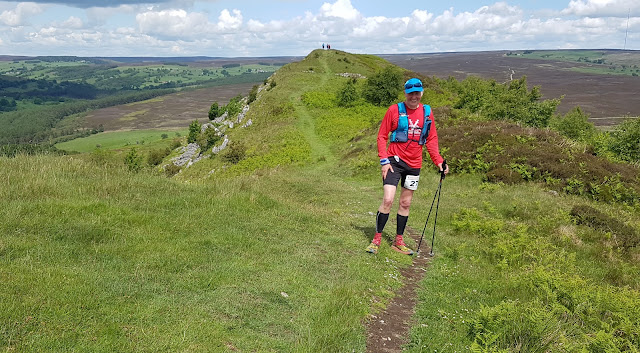
There was a fair bit of gentle climbing with lovely views once we had reached the top.


The weather had been cloudy and warm at the start, but after three miles it started to gently drizzle which was lovely and cooling.

Through woods and on to the first checkpoint. Shortly after this we chose not to follow my drawn route as the path we were going to go down was heavily overgrown with nettles.

On to Haddon Hall and then a climb through fields to Over Haddon


and then on to Sheldon where the route undulated a bit. We also went through a field where a farmer was muck spreading. My sense of smell is not as good as it used to be so this wasn't too too bad for me, but Melanie really did not enjoy that !

We past what was left of Magpie Mine.


We made a minor error but soon got back on track. At the Sheldon checkpoint we were advised that the suggested route in the Village Hall was a bit steep and slippery so we decided to stick to the route on our watches and go down into the lovely Deep Dale.


On into Monsal Dale, following the river


then up to the viaduct in the picture above and along an old railway line before leaving it to head towards Cressbrook Mill.


We past close to the weir at the Mill


before moving on to Cressbrook Dale where it was quite technical underfoot in the woods. The woods soon ended and it got easier


Through Foolow and on into Eyam. Here my route design went wrong. There was a road which was the direct route, but when I looked at it when designing the route, I assumed we should stick to footpaths, so that is what I plotted. Sadly the route I designed took us up a fairly big hill and then down the other side back to the road. The road did not involve any climbing and even better was closed for vehicles, so we could have run along it very safely.

Here is Melanie almost at the top, before she had realised this wasn't a hill we needed to have climbed....


On to the outskirts of Froggart and a lovely run alongside the river before we came to our next decision point on which way to go. We could go along the river to Calver Mill (which was the route on our watches) or go straight up a big hill straight into Calver. Again this wasn't a difficult choice, the path going straight up was completely overgrown with nettles, so on to Calver Mill and then into Calver.

From there we had the steepest climb of the day up to Bramley Wood. At the top there were rhododendrons which were lovely and some of them had had their flowers blown onto the ground.


We could see Baslow in the distance but still over two miles to go


Some attractive views of poppy fields


Then downhill towards Baslow we went on a path though an entire field of poppies, which was just gorgeous


Back to the Village Hall for pie and peas


followed by fruit salad and cream and tea. A lovely way to end the run


As usual in these events, we had a certificate and badge to take away


I think we may well do this one again, we loved it !

Wednesday, 12 June 2019

Hardmoors White Horse 2019

My fifth time at this event and Melanie's second time. I do love this route the scenery is lovely, but it is far from easy with some big hills to climb up.


The start is at the Sutton Bank Visitor Centre and after registration we listen to Jon's briefing.


The event basically starts with a descent down off the escarpment, a loop of Gormire Lake followed a big climb back to the top of the escarpment and once at the top there are some wonderful views. The weather was pretty good, a mixture of sun and cloud with a cooling breeze.


Past the Sports Sunday photographer, we need to work on our timing...


and on to lovely views across the moors from Steeple Cross


and on to the descent into the lovely Thorodale


On to Hawnby and up to Hawnby Hill. This is a tough climb and I felt it more than I should have done


A bit of a steep descent off the north end of the hill.


On to Bilsdale West Moor (another climb)


Down the other side, back into the south end of Hawnby, before a long road climb - the hill on the left is Hawnby Hill which was earlier.


There is a path around this ford, but maybe getting our feet wet might have been a good idea, it was getting warm.


Heading towards Rievaulx Abbey


We stopped at the Visitor Centre and bought some ice cream, which was lovely and refreshing. Now just five miles or so to go and most of it is a drag uphill. There are still some lovely spots, here we are at Grass Keld.


Got back to Sutton Bank in about 6hr 50min and that was fine. I struggled a bit more than I expected as we haven't done much distance recently, but work has been very busy and that may have contributed.

The marshalls, the volunteers and Jon and Shirley were all wonderfully supportive 😃

Sunday, 19 May 2019

Ingleborough Challenge marathon 2019

This was a new event for Melanie and I, I cannot recall how we came across it. I was holding out a slight hope that it might circumnavigate Ingleborough rather than go up it but that was not to be. We have been up Ingleborough on a marathon before - the Settle Saunter (which has since been re-routed to be less than a marathon). We enjoyed that one so I wasn't too disappointed that we were going to the summit. My hope for circumnavigation was to do with having done two marathons in the last two weeks, the second one being particularly hilly, I was wondering what state would my legs be in for more climbing. As it turned out climbing wasn't going to be too much of a problem.....

The event started at Clapham and was being organised by the Cave Rescue Organisation. They had a good system for checking that everybody who checked in to get their number actually started the event. They had marshalls and/or signs at most tricky navigation spots.

The race starts uphill and goes through a couple of tunnels that we had encountered at the Settle Saunter.


After this it just continues mostly upwards all the way to the summit of Ingleborough, about six miles into the route. Thanks to Melanie for some of these photos


The summit is the hill to the left of centre on this photo


We made it to the summit in about 90 minutes which we were very happy with.


There had been one bit where you would not want have wanted to go off the path to the right, there was a big drop. I haven't got the best head for heights but it wasn't too bad on the way up. We had to double back down that way and I took it nice and easy.

It then got a bit easier, we had now separated from the way we had come up and were heading in the direction of Chapel-le-Dale


but this was a false dawn as we came to a section which was extremely steep. I could have managed this fine going up, but down I found very, very challenging going down. I was quite scared. The poles helped a bit but sometimes got in the way. Melanie estimated we did about a mile and half in an hour and this was nothing to do with her. These photographs do not convey the steepness !


Finally it flattened out and I caught up with Melanie who would have had time to eat a two course meal in the time she had to wait for me. We started to speed up a bit, we were the last of the marathon runners at this point although we had passed a couple of marathon walkers (who had set off an hour ahead of us)


Ingleborough and 'that descent' behind Melanie


Checkpoints were just water stations on this event and at the next one we left behind the crowds who were doing the three peaks. Gradually we started to overtake other runners.

We had not expected to see this Ribblehead Viaduct so this was a nice surprise.


The route was now across fields, moors, under railway lines, across bridges, along the Pennine Bridleway and the Pennine Way. Undulating but nothing challenging


We came down the Pennine Way into Horton in Ribbledale, over the railway line and up again


Then a lovely gentle descent on a path with bluebells


A few more climbs (and a couple of minor navigation errors as we now getting tired) before we made it back to the tunnels and into Clapham - back in about 6hr 45min and we were happy with that. This was followed by tea and cake in the Cave Rescue building 😀